


drome

Evelyne et Francois
User

Length
6.5 km

Max alt
616 m

Uphill gradient
141 m
Km-Effort
8.3 km

Min alt
513 m

Downhill gradient
129 m
Boucle
No
Creation date :
2021-03-15 09:28:04.21
Updated on :
2021-03-15 12:49:59.665
2h18
Difficulty : Very easy

FREE GPS app for hiking
 SityTrail
IGN / Geographical institutes
SityTrail Plus
The world is yours!
About
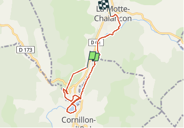
Trail Walking of 6.5 km to be discovered at Auvergne-Rhône-Alpes, Drôme, La Motte-Chalancon. This trail is proposed by Evelyne et Francois.
Description
balade 2
Positioning
Country:
France
Region :
Auvergne-Rhône-Alpes
Department/Province :
Drôme
Municipality :
La Motte-Chalancon
Location:
Unknown
Start:(Dec)
Start:(UTM)
688564 ; 4927050 (31T) N.
Comments